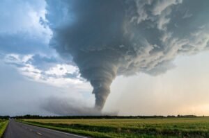

A slow-moving storm front is stirring up serious flash‑flood danger from D.C. to New York City, and no, this isn’t some light drizzle—risk levels are elevated for up to 23 million people.
What You Need to Know
Widespread Flood Watches
Flood watches are in effect across Connecticut, New York, New Jersey, eastern Pennsylvania, Maryland, Washington D.C., and northern Virginia through Friday. This is the real deal—not your average passing shower.Rainfall That France Would Envy
Expect rainfall up to 2 inches per hour, with some totals reaching 4–6 inches locally. Easily fast enough to swamp roads, subways, and even cars.States of Emergency & Travel Advisories
New Jersey has declared a state of emergency, and NYC’s mayor warned residents to skip basement dwellings and avoid commuting Thursday afternoon.Impact Window = Afternoon & Evening
Dangerous downpours are expected during and after rush hour, especially between 2 PM and midnight—exactly when most people are on the roads.The Climate Angle
The humid air feeding this storm is linked to rising sea surface temperatures. Experts warn these types of heavy rain outbreaks are becoming more common—and more extreme.
Readovia Rundown
| Focus | Why It Matters |
|---|---|
| Multiple metro areas affected | D.C., Baltimore, Philly, NYC all at risk |
| Urban flooding—not just roads | Streams, subways, basements vulnerable |
| Travel over highways? Beware | Highways could become dangerous quickly |
| Wall-to-wall alerts | Watches and warnings now active region-wide |
| Weekend rebound ahead | Sunshine and cooler air return Friday into the weekend |
Bottom Line
This isn’t a random flash in the pan. It’s a significant weather event along the I‑95 corridor with potential for serious disruption and damage. If you’re in the region: check flood alerts, skip unnecessary travel, and have a backup plan for evening plans.